10 Best Hiking Trails in Westfjords Iceland: Guide & Map
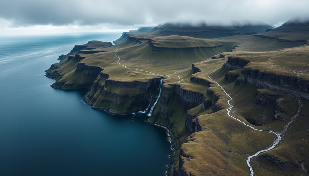
There’s a quiet corner of Iceland that even many seasoned travellers miss: the Westfjords. This region holds some of the country’s most dramatic hiking trails, from short waterfall walks to multi-day wilderness treks.
Number of marked trails: 10+ (AllTrails) · Area of Hornstrandir Nature Reserve: 580 sq km · Height of Dynjandi waterfall: 100 m · Valagil waterfall trail length (one way): 1.5 km · Typical hiking season: June–September
Quick snapshot
- Dynjandi waterfall hike is a short 1.5 km round-trip easy trail accessible from road 60 (Our Wanders)
- Hornstrandir Nature Reserve has no roads or services and requires registration (Guide to Iceland)
- Látrabjarg coastal trail offers variable length with medium difficulty and cliff-edge hazards (Our Wanders)
- Exact current trail conditions after winter storms can change rapidly
- Marking quality on lesser-known trails (e.g., Vatnsdalur loop) may be inconsistent
- Ferry operators to Hornstrandir may differ seasonally
- Snowmelt timing in high-elevation passes varies yearly by weeks
- Trail conditions are updated annually; always check recent reports before departure
- Permit requirements for Hornstrandir remain stable year to year
- Check official sites for current trail conditions and ferry schedules
- Download offline GPS tracks before leaving cell reception
| Number of trails (AllTrails) | 10+ |
| Trail types | Valley, mountain pass, coastal, waterfall |
| Typical elevation gain | 200–500 m |
| Peak season | June–September |
| Permit requirement (Hornstrandir) | Yes |
What are the best hiking trails in the Westfjords?
Dynjandi (Fjallfoss) Trail
- Short 1.5 km round-trip with almost no elevation gain; family-friendly and accessible from road 60 (Our Wanders hiking guide)
- The tiered waterfall cascades 100 m and is one of Iceland’s most photographed spots
Hornstrandir Nature Reserve
- A remote wilderness spanning 580 sq km with zero services — visitors must be fully self-sufficient (Guide to Iceland hiking overview)
- Home to Arctic foxes and high bird cliffs; classic multi-day trek from Horn to Horn takes 4–5 days
- Registration with the Environment Agency of Iceland is mandatory (Icelandic Environment Agency protected areas)
Látrabjarg Bird Cliffs
- Variable-length coastal trail with medium difficulty; cliff-edge hazards due to bird photography (Our Wanders hiking guide)
- Europe’s largest bird cliff, home to puffins, gannets, and razorbills
Hörgur Cliff Circular
- 30-minute to 1-hour loop from Hörgsnes parking lot, only 10 m elevation gain (Icelandic Environment Agency hiking trails data)
- Excellent for a quick leg-stretcher with coastal views
Þingmannaheiði Circular
- Strenuous 24 km route requiring about 6 hours and 500 m elevation gain (Icelandic Environment Agency hiking trails data)
- Traverses mountain heath with panoramic views of Vatnsfjörður
The pattern across these five trails is clear: the easier ones (Dynjandi, Hörgur) give you the iconic waterfall or cliff views with almost no effort, while the moderate and difficult routes (Hornstrandir, Þingmannaheiði) demand self-sufficiency and navigation skills. No single trail is “best” for everyone; the real best trail is the one that fits your fitness, time, and tolerance for unpredictability.
Where can I find a hiking trail map of the Westfjords?
Online resources
- AllTrails lists 10+ Westfjords trails with GPS coordinates, user reviews, and photos (AllTrails Westfjords collection)
- Wikiloc offers community-uploaded GPX tracks for many routes
Official tourism maps
- The official Westfjords tourism site provides printable PDF maps with trailheads and points of interest (Westfjords Iceland tourism authority)
- Local visitors centres in Ísafjörður and Patreksfjörður distribute free paper maps during summer
Topographic maps and GPS tracks
- For remote areas like Hornstrandir, carry a 1:50,000 topographic map available from the Icelandic Institute of Natural History
- Download offline GPS tracks before heading out — cell service is sparse
The implication: no single map covers all the Westfjords. Use AllTrails for planning and route previews, then pick up a paper map at a visitor centre for backup. In the backcountry, a GPS device or phone with offline maps is essential — trails are not signposted once you leave the main paths.
How difficult are the hikes in the Westfjords?
Easy day hikes
- Dynjandi: 1.5 km round trip, flat, family-friendly
- Vatnsdalur loop: 2 km, 50 m elevation gain, 1 hour (Icelandic Environment Agency hiking trails data)
- Hörgur cliff circular: 30 min–1 hour, 10 m gain
Moderate routes
- Látrabjarg cliff walk: variable length, medium difficulty, cliff hazards
- Lónfell from Dynjandaheiði: 5–6 km, 300 m gain, 3 hours (Icelandic Environment Agency hiking trails data)
- Coastal paths in Hornstrandir: generally moderate with river crossings and uneven terrain
Challenging mountain traverses
- Þingmannaheiði circular: 24 km, 500 m gain, 6 hours
- Horn to Horn trek in Hornstrandir: 4–5 days, requires navigation and river crossings
- Korpudalur and Álftarfjörður: unmarked trails, only for experienced trekkers
Easy hikes like Dynjandi require zero navigation but offer quick photo stops. Moderate routes demand basic map reading. Challenging traverses, especially in Hornstrandir, assume you can handle bad weather, river crossings, and route-finding without cell reception. The Westfjords do not cotton to the unprepared.
The catch: most Westfjords trails are unmaintained. Even the “easy” ones can become slippery or indistinct after rain. Assume every trail is harder than its distance suggests, especially in Hornstrandir where there are no facilities or rescue services nearby.
What is the Hornstrandir Nature Reserve and how do I hike there?
Permits and regulations
- Registration with the Environment Agency of Iceland is mandatory for all overnight visitors (Icelandic Environment Agency Hornstrandir page)
- Camping is allowed only in designated sites; open fires are prohibited
- Respect the fragile tundra — stay on trails and pack out all waste
Access by ferry
- Ferries depart from Ísafjörður to key trailheads such as Horn and Hesteyri (seasonal, June–September)
- Advance booking is essential — seats sell out weeks ahead
Recommended multi-day itineraries
- Classic Horn to Horn trek: 4–5 days, roughly 40 km, coastal cliffs and bird colonies
- Shortened 2–3 day option from Hesteyri to Horn, suitable for moderate hikers
Why this matters: Hornstrandir is the ultimate Westfjords hiking experience, but it’s not a casual outing. The reserve’s isolation means you must carry all gear, food, and emergency supplies. One wrong turn could cost hours. If you’re not comfortable with route-finding in remote terrain, consider hiring a local guide for at least the first day.
- Register with the Environment Agency of Iceland at least two weeks before your departure date
- Book your ferry from Ísafjörður — slots fill quickly and cancellations are rare
- Pack all food, fuel, and emergency supplies for the full duration plus one extra day
- Download offline GPS tracks and carry a 1:50,000 topographic map as backup
- Inform a contact of your exact itinerary and expected return time
These steps convert an overwhelming planning process into manageable tasks. The pattern: preparation beats improvisation in Hornstrandir every time.
Are there hot springs along the hiking trails in the Westfjords?
Krossneslaug pool
- A geothermal pool perched on the coast near Krossnes, accessible via a short walk from the road
- Stunning ocean views, but the pool is small and can be crowded in summer
Hellulaug hot spring near Flateyri
- A natural hot pot with temperatures around 39°C, a 15-minute walk from the town of Flateyri
- Unofficial and unmarked — ask locals for directions
Natural hot pots in remote valleys
- Several unmarked hot springs exist in the valleys of Reykjanes and near the Lónfell trail
- These require local knowledge; guidebooks or recent blog reports are your best bet
The pattern: none of these hot springs are on marked hiking trails. They are side trips. The ones easiest to reach (Krossneslaug, Hellulaug) require only a short walk, while remote hot pots demand additional navigation and are best included in multi-day itineraries with a guide.
| Trail | Distance | Elevation gain | Difficulty | Best for |
|---|---|---|---|---|
| Dynjandi | 1.5 km round trip | Negligible | Easy | Families, quick stops |
| Vatnsdalur loop | 2 km | 50 m | Easy | Short leg-stretcher |
| Hörgur cliff | ~1 km loop | 10 m | Easy | Coastal views, quick hike |
| Látrabjarg cliffs | Variable (up to 10 km) | Minimal | Moderate (exposure) | Birdwatching, photographers |
| Lónfell | 5–6 km | 300 m | Moderate | Valley and mountain views |
| Þingmannaheiði | 24 km | 500 m | Challenging | Experienced hikers |
| Horn to Horn (Hornstrandir) | ~40 km over 4–5 days | Variable (up to 800 m total) | Challenging | Multi-day expedition |
Seven trails, one pattern: the easiest give quick rewards with minimal effort, while the challenging routes demand serious preparation. The standout is Þingmannaheiði — a full-day 24 km trek with 500 m gain that few casual hikers attempt, yet it offers some of the most pristine heathland in Europe.
Clarity check
Confirmed facts
- Valagil trail is 1.5 km one way (Wild Westfjords regional guide)
- Hornstrandir requires registration (Icelandic Environment Agency Hornstrandir page)
- Dynjandi is accessible by car from road 60
- Most gravel roads in the Westfjords are passable with a normal car in dry summer conditions
What’s unclear
- Exact current trail conditions after winter storms — always check recent reports
- Availability of marked paths for some lesser-known trails (e.g., Korpudalur)
- Ferry operators to Hornstrandir may change seasonally; confirm before booking
- Snow cover duration on high passes such as Þingmannaheiði varies annually
“The most common mistake we see is people underestimating how quickly the weather can change. You can go from sunshine to horizontal sleet in ten minutes. Always carry a waterproof layer and a map.”
— Westfjords tourism safety officer
“The Horn to Horn trek is the crown jewel of Iceland hiking. But it’s not a walk in the park. You need to be comfortable with river crossings, navigating without trail markers, and carrying a week’s worth of food.”
— Local guide, Hornstrandir Expeditions
The Westfjords offer some of Iceland’s most rewarding hiking, but the reward is proportional to the preparation. Easy trails like Dynjandi and Vatnsdalur give you a taste of the landscape in under two hours. Moderate routes like Látrabjarg and Lónfell require basic fitness and map skills. And the multi-day treks in Hornstrandir demand full self-sufficiency. The independent hiker must match ambition to gear and training — or accept that the Westfjords will humble you.
Frequently asked questions
Do I need a guide to hike in Hornstrandir?
No, it’s possible to hike independently after registering with the Environment Agency of Iceland. However, if you’re unfamiliar with unmarked trails or river crossings, a guide adds safety and local knowledge.
What is the best time of year for hiking in the Westfjords?
The typical hiking season runs from June to September. July and August offer the most stable weather and longest daylight hours, but trails remain snow-free only from late June onward in higher elevations.
Are the trails in the Westfjords well marked?
Only the most popular trails (Dynjandi, Vatnsdalur) have clear markers. Many routes rely on cairns and worn paths. Even the marked ones can be faint after winter. Always carry a map and GPS backup.
Can I camp along the hiking trails?
Wild camping is permitted outside protected areas, but in Hornstrandir Nature Reserve camping is allowed only in designated sites. In other areas, follow Icelandic leave-no-trace principles: camp on bare ground, away from vegetation, and pack out all waste.
Is there public transport to trailheads?
Public bus routes reach Ísafjörður and Patreksfjörður, but most trailheads require a rental car. Ferry services from Ísafjörður serve Hornstrandir trailheads. Ridesharing is rare but possible in summer.
What wildlife might I encounter on Westfjords hikes?
Arctic foxes are common in Hornstrandir. Bird cliffs host puffins, gannets, razorbills, and guillemots. Seals can be seen along the coast. There are no large predators or poisonous snakes in Iceland.
How do I prepare for sudden weather changes in the Westfjords?
Check the Icelandic Meteorological Office forecast (Icelandic Met Office weather service) before every day’s hike. Pack a waterproof jacket and trousers, a warm mid-layer, hat, gloves, and a map. Winds can exceed 30 m/s on exposed ridges.
More related posts
 Michael B. Jordan Movies: Full Filmography & Guide
 The Courage to Be Disliked: Summary, Review & Insights
 Irish Ferries Rosslare to Pembroke: Timetable, Prices & Tips
 Pictures of Cellulitis on Legs: Symptoms & Healing Guide
 Fuel Allowance Ireland: Partial Payment Warning Explained
 Wexford Bus 740A Timetable: Leap Card, Cash & Live Tracking
 Hotel Costa Malaga by Pierre & Vacances – Reviews Location Guide
 Naruto Shippuden Filler List: Every Episode You Can Skip