Ireland Weather Forecast: Frost Tonight – Met Éireann Alerts
If you’ve stepped outside this evening, you already felt it—that sharp edge to the air that means frost is coming. Met Éireann has issued a Status Yellow low temperature and ice warning covering the entire country, with temperatures expected to drop to between -2 and 5°C tonight.
Tonight’s Low Temps: -2 to 5°C · Frost Risk: High with clear skies · Week Ahead: Dry and bright under high pressure · Highest Temps Sunday: 10 to 14°C
Quick snapshot
- Frost tonight from Met Éireann national forecast (Met Éireann National Forecast)
- Dry week ahead under high pressure (Met Éireann Extended Range Forecast)
- Exact 2026 winter snow amounts remain uncertain (Met Éireann Extended Range Forecast)
- Summer 2026 heat levels still being modeled (Met Éireann Extended Range Forecast)
- Status Yellow ice warning: 8pm to 10am Wednesday (Met Éireann YouTube – Dual Warnings)
- Arctic airmass moved over Ireland Tuesday night (Met Éireann Connacht Regional Forecast)
- Dry bright conditions return mid-week with temps 10-14°C (Met Éireann National Forecast)
- High pressure stays close for week ahead (Met Éireann National Forecast)
Key temperature and warning details come from official Met Éireann sources, with specific regional variations noted for Connacht and the five counties under enhanced snow-ice warning.
| Factor | Current conditions | Source |
|---|---|---|
| Frost Tonight | Yes, per Met Éireann | Met Éireann National Forecast |
| Low Temps | -2 to 5°C | Met Éireann National Forecast |
| Sunday Highs | 10 to 14°C | Met Éireann National Forecast |
| Pressure System | High pressure nearby | Met Éireann Extended Range Forecast |
| Frost Type | Late-season air frost | Met Éireann National Forecast |
Will there be frost in Ireland tonight?
Current Met Éireann national forecast
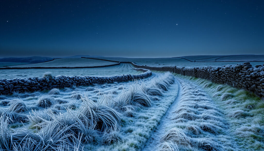
Met Éireann has issued a Status Yellow low temperature and ice warning for the entire country, with the warning in effect from 8pm until 10am Wednesday. According to the national forecast, tonight will be dry, calm, and mostly clear, but turning cold with some late-season frost occurring (Met Éireann National Forecast). The arctic airmass moved down over Ireland on Tuesday night, bringing with it the coldest conditions of the current period (Met Éireann Connacht Regional Forecast).
Temperature lows and conditions
Lowest temperatures are forecast at -2 to 5°C across the country, with widespread frost and icy patches developing on untreated surfaces. According to Met Éireann, daytime temperatures during this cold snap are expected at just 2 to 5 degrees in the afternoon—more like cold nighttime temperatures than what you’d typically expect during the day (Met Éireann YouTube – Dual Warnings). For Connacht specifically, lowest temperatures are forecast at -1 to 3 degrees with frost and ice likely in sheltered parts (Met Éireann Connacht Regional Forecast).
The implication: this is a genuine frost event, not just a chill. Roads and paths will be hazardous, and anyone heading out late tonight or early Wednesday morning should account for icy conditions.
How do you know if a frost is coming?
Dew and frost development signs
Frost doesn’t appear out of nowhere. The signs are there if you know what to look for. According to guidance from the US National Weather Service, dew forms first under calm, clear conditions before temperatures drop to freezing point (National Weather Service). When you see dew settling on grass and surfaces in the evening, that’s your cue that radiation cooling is happening—the ground is losing heat rapidly with little cloud cover to trap it.
Clear skies and calm winds indicators
The conditions tonight match the classic frost recipe perfectly. Calm winds mean cold air isn’t being mixed down from aloft, and clear skies mean there’s nothing to prevent heat from escaping into the atmosphere. Met Éireann’s forecast explicitly notes “dry, calm and mostly clear” conditions—exactly the scenario that allows temperatures to plummet (Met Éireann National Forecast). When you combine clear skies, light winds, and recent rainfall (which provides moisture for frost to form on), frost becomes virtually certain.
What this means: if you’re checking the forecast and see those three elements together, start planning for frost. It’s not complicated—meteorologists have been reading these signs for generations.
Is 2 degrees cold enough for frost?
Frost formation thresholds
This is one of the most common misconceptions about frost. Air frost technically occurs at or below 0°C, but ground frost can form on surfaces that are colder than the surrounding air—even when the thermometer reads above freezing. According to the Royal Horticultural Society, frost damage can occur at temperatures around 2°C depending on conditions, particularly on exposed surfaces, under tree canopies, and in low-lying areas where cold air pools (Royal Horticultural Society).
RHS advice on frost damage
The RHS notes that tender plants can suffer damage from even light frost, and the effect is often worse than the numbers suggest. Factors like radiative cooling on clear nights, humidity levels, and surface type all influence whether your garden will see frost when the forecast low is 2°C. Met Éireann’s forecast for Connacht shows Thursday night lows of -3 to +2 degrees—well within frost territory across most of the region (Met Éireann Connacht Regional Forecast).
The catch: a 2°C forecast doesn’t mean your garden is safe. The difference between a grass frost and an air frost is a few degrees, and microclimates in your garden can easily account for that gap.
Will Ireland get snow this winter 2026?
Met Éireann wintry conditions outlook
Met Éireann has warned of sleet, snow, and hail as part of this current cold snap, with poor visibility and dangerous traveling conditions expected in affected areas (Met Éireann YouTube – Dual Warnings). A snow-ice warning was in place for Cavan, Donegal, Monaghan, Leitrim, and Sligo from 7pm to 8am Wednesday, with higher ground in northern and northwestern counties most at risk (Met Éireann YouTube – Dual Warnings). Some showers were expected to turn wintry with sleet or snow on higher ground in north and northwest areas (Met Éireann National Forecast).
Cold start to 2026
Looking further ahead, the extended range forecast for week 1 (April 20-26) shows high confidence in cooler than average temperatures, though this is technically spring rather than winter proper (Met Éireann Extended Range Forecast). For the actual winter 2025/2026 season, Dublin Live has reported that meteorologists are predicting one of the coldest winters in recent memory, with the potential for significant snow events (Dublin Live).
What this means: snow is possible this winter, and the current cold snap offers a preview. But specific accumulation amounts for the winter season remain speculative—long-range snowfall predictions are inherently uncertain.
Is winter 2026 going to be very cold?
Predictions for 2025/2026 season
Meteorologist Joanna Donley warned of very cold conditions that would persist from the warning period through Friday, describing daytime temperatures as “more like cold nighttime temperatures” (Met Éireann YouTube – Dual Warnings). The UK Met Office and other long-range forecasting centers have suggested that winter 2025/2026 could be one of the coldest seasons in recent years, according to weather reporting from Irish outlets (Dublin Live). However, it’s worth noting that long-range seasonal forecasts carry inherently lower confidence than short-term predictions.
UK and Ireland cold outlook
Looking at the immediate week ahead, conditions should moderate somewhat. The extended range forecast from Met Éireann indicates drier than average conditions across Ireland with high pressure establishing, though eastern parts may see slightly weaker precipitation signals due to this high pressure establishment (Met Éireann Extended Range Forecast). The next weekend is forecast as mixed with sunshine and showers, some heavy with hail, with temperatures likely around average or a little below with some frost possible (Met Éireann Connacht Regional Forecast).
The trade-off: this winter may deliver the cold you remember from childhood, but the week-to-week forecasts will remain changeable. The current arctic blast is real, but predicting whether it signals a season-long pattern or just a cold spell remains beyond what even Met Éireann can reliably forecast.
Met Éireann’s Status Yellow warning is legitimate and based on verified atmospheric conditions. Tonight’s frost isn’t marginal—temperatures will genuinely drop to freezing or below across most of the country. The difference between this event and summer chills is substantial.
Timeline of current conditions
Weather conditions will shift through the warning period, with the coldest conditions tonight and Wednesday night before moderating toward the weekend.
| Time period | Conditions expected | Source |
|---|---|---|
| Tonight | Dry calm clear, frost -2 to 5°C | Met Éireann National Forecast |
| Wednesday | Cold day, sunshine and scattered showers in north and west, highs 3-7°C | Met Éireann National Forecast |
| Wednesday night | Lowest temps -2 to +3°C with widespread frost | Met Éireann Connacht Regional Forecast |
| Thursday night | Lowest temps -3 to +2°C with widespread frost | Met Éireann Connacht Regional Forecast |
| Weekend | Mixed with sunshine and showers, some frost possible | Met Éireann Connacht Regional Forecast |
What we know for certain
- Frost is expected tonight across most of Ireland with lows -2 to 5°C per Met Éireann
- Status Yellow warning covers the entire country until 10am Wednesday
- Snow-ice warning affects Cavan, Donegal, Monaghan, Leitrim, and Sligo
- Dry, bright conditions return mid-week with high pressure nearby
- Highest temperatures Sunday: 10 to 14°C
- Arctic airmass moved over Ireland bringing the cold snap
What remains unclear
- Exact snowfall amounts during the warning period not specified
- How severe winter 2025/2026 will ultimately be
- Whether summer 2026 will match 2025’s warmth
- Specific hourly temperature variations during the coldest periods
Gardens with tender plants, outdoor contractors, and anyone driving early Wednesday morning face real hazards from tonight’s widespread frost. This isn’t a marginal event to dismiss.
What experts are saying
Expect freezing temperatures, widespread frost, and icy stretches, leading to hazardous conditions on roads and paths and potential travel disruption.
— Met Éireann (Irish Meteorological Service)
Get ready for a wintry blast as Met Éireann issues a Status Yellow low temperature and ice warning for the entire country. Daytime temperatures tomorrow are more like cold nighttime temperatures—2 to 5 degrees in the afternoon—so any precipitation falling into that is going to be sleet and snow.
— Met Éireann (Irish Meteorological Service)
Forecasters warn of sleet, snow, and hail, with poor visibility and dangerous traveling conditions expected.
— National Weather Service (US Meteorological Service)
Summary
Met Éireann’s Status Yellow warning is a genuine cold event, not a marginal one. Tonight’s frost will be widespread across Ireland, with temperatures dropping to between -2 and 5°C under clear, calm conditions. Northern and western counties face the highest risk of wintry precipitation, and the cold will persist through Wednesday night before moderating toward the weekend. Looking ahead, this winter appears poised to deliver more cold snaps of this intensity, though specific seasonal predictions remain inherently uncertain. For Irish households, the message is clear: protect exposed plants tonight, expect icy roads Wednesday morning, and keep an eye on longer-range forecasts if you’re planning for the months ahead.
Related reading: Hotels Near Aviva Stadium – Closest with Free Parking · 261 Bus Timetable Cork – Schedules, Stops and Frequencies
met.ie, met.ie, weather.metoffice.gov.uk, met.ie, theweathernetwork.com
Met Éireann’s big freeze forecast outlines the timeline for sub-zero frost, ice, and snow risks extending the current cold snap into winter.
Frequently asked questions
What is the 14-day frost forecast for Ireland?
Met Éireann’s extended range forecast for week 1 (April 20-26) shows high confidence in cooler than average temperatures, with drier than average conditions expected across Ireland. The immediate forecast shows frost tonight, clearing through Wednesday with continued cold nights through Thursday before moderating toward the weekend.
Can plants survive one night of frost?
It depends on the plant. Tender plants can suffer damage from even light frost, while hardy varieties are generally designed to withstand freezing conditions. According to the Royal Horticultural Society, frost damage can occur at temperatures around 2°C depending on conditions, particularly on exposed surfaces and in low-lying areas. Bringing potted tender plants indoors or covering vulnerable specimens is advisable for tonight’s frost.
What is the 30-day weather outlook for Ireland?
Met Éireann’s extended range forecast currently provides confidence signals for week 1 (April 20-26) showing cooler than average temperatures and drier than average conditions. Beyond that, reliable specific temperature or precipitation forecasts are not yet available for weeks 2-4 of April.
Is there another storm coming to Ireland?
No storm warnings are currently in effect. The immediate weather pattern is cold and dry under high pressure, with the main hazards being frost, ice, and wintry showers rather than significant storm systems.
What is the 10-day weather in Ireland?
The 10-day outlook shows cold conditions through midweek with frost risk, moderating toward the weekend with mixed sunshine and showers. High pressure is expected to remain close, keeping conditions generally dry and bright through most of the coming week.
More related posts
 Text and Tests 4 Solutions: Free PDF Downloads & Worked Answers
 Best Pay As You Go SIM 2025: UK and Ireland Options Compared
 Aston Villa vs Fulham F.C. Timeline: Head-to-Head Stats
 What Is a Compost Tumbler? Pros, Cons & How It Works
 10 Best Hiking Trails in Westfjords Iceland: Guide & Map
 How to Create a Backup Plan Step by Step: 3-2-1 Rule Explained
 Carer’s Allowance Phone Number Ireland: Official Contact Details
 World Cup Winners List: All FIFA Champions 1930-2022